
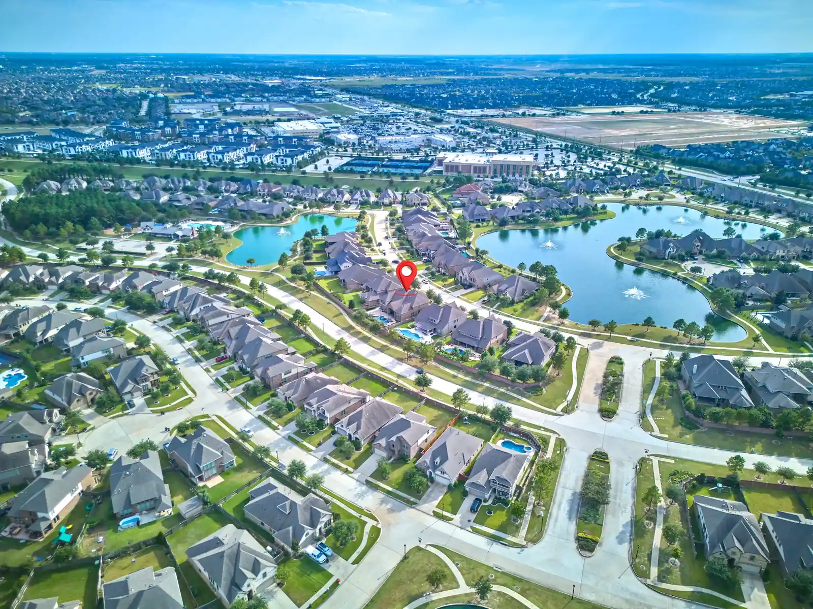
107 Twin Oaks Way · Property & setting
Drone Photography and Video for Houston Real Estate
The home.
The whole picture.
The whole picture.
Drone photography and video for Cypress, Katy, Bridgeland and Greater Houston. Show the property, its setting and what surrounds it.

PRO360 PHOTOS / A DIFFERENT PERSPECTIVEDrone photo add-ons from $95 ↗
AERIAL FILMS / TWO PERSPECTIVESSee the setting.
See the setting.
Feel the scale.
From a waterfront home in Kemah to open land in Caldwell. See how drone video brings the property and its surroundings together.
2716 County Road 324 · Land & surroundings
Previews play silently while in view. Select a film to watch it in full with sound.
PRO360 PHOTOS / AERIAL PORTFOLIOA perspective
A perspective
you cannot get from the ground.
Explore homes, outdoor spaces, land and surrounding views. Open any photograph for a closer look.
10 photographs · All photos
THE PROPERTY IN CONTEXTMore than a roof.
More than a roof.
A clearer view of the setting.
Aerial media adds context to your interior and exterior photos. Use it when the lot, outdoor features or surroundings are part of the property story.
The home + outdoor living
Show how the house, pool, patio and garden fit together. A carefully chosen elevated view can explain features that separate ground-level photographs cannot.
The location + surroundings
Give buyers a wider view of nearby streets, green space and visible amenities. Tell Mario which surrounding features matter to the listing so feasibility and access can be reviewed.
Land + larger properties
Show the relationship between buildings, open space and access routes. Aerial images are a visual overview, not a survey or proof of property boundaries.
AERIAL SERVICES / USD
Choose your perspective.
Book aerial photos, drone video or a 360° panorama. Selected listing packages also include drone photography; compare exact inclusions before ordering.
Drone photography
| 5 images | $95 |
|---|---|
| 10 images | $155 |
| 20 images | $245 |
Aerial perspective, surrounding views and location clarity.
Drone rates are same-visit add-ons. Drone-only appointments are available by request, starting from $150. Request a quote.
Plan this coverage ↗Drone video
| 30 seconds | $125 |
|---|---|
| 1 minute | $195 |
| Bundle: 10 photos + 1-minute video | $295 |
Professional drone video gives the listing a moving view of the property and its setting.
Plan this coverage ↗Aerial 360 panorama
| 1 image / location | $95 |
|---|
A high-resolution 360° drone panorama showing the property position and surroundings.
Plan this coverage ↗FAA Part 107 certified remote pilot. Coverage depends on the address, airspace, weather and safe operating conditions. Confirm any travel or special requirements when booking.
Compare listing packages ↗BEFORE THE FLIGHTA clear brief.
A clear brief.
A better aerial presentation.
Share the address and your must-show features before the appointment. This helps plan useful views and review flight feasibility.
Clear the visible outdoor areas
Move your vehicles where practical. Tidy bins, hoses, toys and loose pool equipment. Prepare the whole visible yard, not only the front entrance.
Confirm access + requests
Share gate and parking instructions privately. Flag requested community amenities, nearby features and any access restrictions. Do not assume every off-site location can be included.
Keep the plan flexible
Weather and flight restrictions can change. Mario will discuss alternatives if aerial coverage cannot proceed as planned. Agree any revised timing directly.
CYPRESS · KATY · BRIDGELAND · GREATER HOUSTONLocal listings.
Local listings.
A wider perspective.
PRO360 Photos provides aerial photography and video across Greater Houston, including Cypress, Katy, Bridgeland, Tomball, Spring and Montgomery. Flight feasibility is checked for the individual address.
Cypress
Share the property features you want buyers to understand, from the backyard layout to the surrounding setting. Aerial views work best alongside a complete listing photo set.
Katy
For a home with outdoor living, a pool or a larger lot, discuss which elevated angles will explain the relationship between those features.
Bridgeland
If surrounding green space or community context is part of the brief, identify the exact locations in advance. Permission, access and flight conditions determine what can be captured.
ANSWERS BEFORE YOU BOOKAerial media,
Aerial media,
clearly explained.
Prices, delivery and practical flight questions.
Ask Mario: 832 874 5930How much does drone photography cost?
Drone photography is $95 for 5 images, $155 for 10 and $245 for 20. Aerial 360° panoramas are $95 per location. Drone rates are same-visit add-ons. Drone-only appointments are available by request, starting from $150. Selected listing packages include drone photography.
How much does drone video cost?
Drone video is $125 for 30 seconds or $195 for 1 minute. A bundle of 10 aerial photos and a 1-minute drone video is $295.
What is an aerial 360 panorama?
An aerial 360 panorama is a high-resolution view showing the property position and full surroundings from an elevated viewpoint. It costs $95 for one image per location. Confirm the intended viewing or delivery format when booking.
When will I receive my aerial media?
Drone photos and aerial 360 panoramas are delivered with your listing photos by 9 a.m. the morning after the shoot. Drone video is delivered in 2 to 5 days.
Is your drone pilot FAA certified?
Yes. Mario Gerussi flies every PRO360 drone shoot as an FAA Part 107 certified remote pilot. Certification does not mean every flight or location is automatically allowed. Airspace and operating rules still apply.
Can you fly a drone at every property?
Most properties, yes. Mario is an FAA Part 107 certified drone pilot. Some northwest Houston neighborhoods sit in controlled airspace near Bush Intercontinental and Hooks Airport, where flights need FAA authorization, and wind or rain can also stop a flight. If a flight is not safe or legal, the aerial portion is rescheduled at no charge or refunded, your choice.
What happens if it rains or is too windy?
Drone photography and video depend on wind, rain and FAA airspace rules. If a flight isn’t safe or legal, we reschedule the aerial portion at no charge or refund it, at your choice. Read the full booking policy.
Can aerial images show property lines or nearby amenities?
Discuss requested overlays and surrounding locations before booking. Property markers in portfolio examples help orient the viewer; they are not a survey. Any boundary information needs a reliable source and appropriate review. Amenity coverage depends on permission, access and flight feasibility.
YOUR NEXT LISTINGShow the property.
Show the property.
And the bigger picture.
Tell Mario what makes the location worth seeing.
Plan aerial coverage ↗Or call Mario. 832 874 5930